Actual Continent Sizes refer to the surface area of each continent on Earth. The total surface area of all seven continents combined is approximately 150.5 million square kilometers. Each continent has its own unique size, shape, and features. The largest continent is Asia with an area of 44.6 million square kilometers, followed by Africa (30.2 million square kilometers), North America (24.7 million square kilometers), South America (17.9 million square kilometers), Antarctica (13.2 million square kilometers), Europe (10.2 million square kilometers), and Australia (7.9 million square kilometers). The total land area of each continent varies significantly due to the presence of large bodies of water, such as the Arctic Ocean, Pacific Ocean, Atlantic Ocean, and Indian Ocean. In addition, the sizes of the continents are constantly changing due to the effects of erosion, tectonic plate movement, and other geological processes.
Contents
- 1 Actual Continent Sizes
- 2 History of Continental Measurement – Discussion of how continental sizes were determined in the past
- 3 Present Day Measurement of Continental Sizes – Overview of current methods and technology used to measure sizes of continents
- 4 Actual Sizes of Continental Areas – Discussion of the actual sizes of the various continents compared to traditional estimates
- 5 Conclusion
Actual Continent Sizes
The actual size of continents is often surprising to people. While most people are aware that the landmass of Africa is the largest continent, they may be surprised to learn that Asia is actually the largest continent by both landmass and population. Europe, while not the largest landmass, is the second most populous continent. North America ranks third in both population and landmass, while South America is the fourth largest continent in terms of landmass and population. Australia is the smallest continent in terms of landmass, but still has a sizable population. Antarctica is the least populated and smallest continent, but is the largest desert in the world.
History of Continental Measurement – Discussion of how continental sizes were determined in the past
The history of continental measurement is an intriguing one, filled with both precise accuracy and educated guesswork. Throughout the centuries, the size and shape of the Earth’s continents have been determined using a variety of techniques, ranging from the earliest observations of sailors and explorers to modern satellite technology.
In the early days, the size and shape of the continents were determined by observation and exploration. Ancient sailors and explorers would traverse the world’s oceans and map out the coastlines of the continents they encountered. As they sailed, they would make notes of the features they saw and the sizes of the landmasses they encountered. This was the first step in determining the size and shape of the continents.
As technology advanced, so did the accuracy of continental measurement. In the 17th century, surveyors and geographers began to use sophisticated surveying instruments, such as the theodolite and the quadrant, to measure the size and shape of the continents. By combining their observations with mathematical calculations, they were able to accurately map out the size and shape of the continents.
In the 18th century, geographers and surveyors began to use triangulation to measure the size and shape of the continents. This involved taking multiple measurements from different points and then using trigonometry to calculate the size and shape of the continent. This method was more accurate than the earlier methods, and allowed for the measurement of much larger landmasses.
In the 20th century, satellite technology revolutionized continental measurement. By using satellites to take pictures of the continents from above, surveyors and geographers were able to accurately measure the size and shape of even the largest continents.

Today, the size and shape of the continents are measured using a combination of techniques, including satellite imagery, aerial photography, and Global Positioning System (GPS) technology. By combining these techniques, surveyors and geographers can accurately measure the size and shape of the continents.
The history of continental measurement is a fascinating one, filled with both precision and guesswork. From the earliest observations of sailors and explorers to the modern use of satellites, each new technique has enabled us to better understand the size and shape of the continents.
Present Day Measurement of Continental Sizes – Overview of current methods and technology used to measure sizes of continents
The world is a vast and ever-changing place, and measuring the size of its continents is no easy feat. Over the centuries, much has been learned about the size and shape of the landmasses that make up the planet’s surface. Today, with the aid of modern technology, it is possible to measure continental sizes with an unprecedented level of accuracy.
One of the primary methods used to measure continental sizes is satellite imagery. By taking high-resolution images of the earth from space, scientists can measure the size of each continent in relation to the others. This data can then be used to create accurate maps and models of the earth’s surface.
In addition to satellite imagery, radar imaging is also used to measure continental sizes. This type of imaging uses radar waves to create a topographic image of the earth’s surface. By measuring the distance between points on the map, the size of each continent can be calculated.
In addition to satellite and radar imaging, other types of technology can be used to measure continental sizes. Global Positioning System (GPS) devices are used to measure the exact coordinates of each continent’s borders. This data can then be used to calculate the continent’s size.
Finally, digital elevation models can be used to measure the size of continents. By measuring the elevation of each point on the map, the size of each continent can be calculated. This is especially useful when measuring the size of mountainous regions.
By combining these various methods of measurement, scientists are able to accurately measure the size of each continent. This data can then be used to create maps and models of the earth’s surface, providing a more accurate picture of the planet’s size and shape.

Overall, the measurement of continental sizes has come a long way since the days of rudimentary maps and measurements. Today, with the aid of modern technology, it is possible to measure the size of the world’s continents with an unprecedented level of accuracy. Through the use of satellite and radar imaging, GPS devices, and digital elevation models, scientists can gain a more detailed understanding of the size and shape of the planet’s landmasses.
Actual Sizes of Continental Areas – Discussion of the actual sizes of the various continents compared to traditional estimates
The world has long been divided into seven main continents, each with its own unique geography, culture, and history. But, have you ever stopped to think about the actual size of these continental areas? When put into perspective, the traditional estimates of the sizes of each continent may have been slightly off.
In reality, the size of the continents differs significantly from the traditional estimates. For example, the largest continent in the world is actually Asia, not Europe, as is commonly believed. This is due to the fact that Europe is a peninsula, and when combined with Asia, it forms Eurasia, which is the largest landmass on the planet.
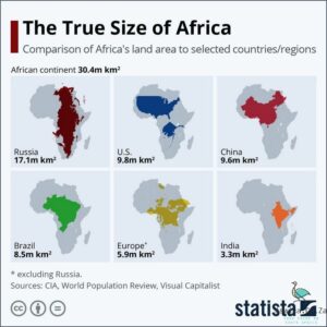
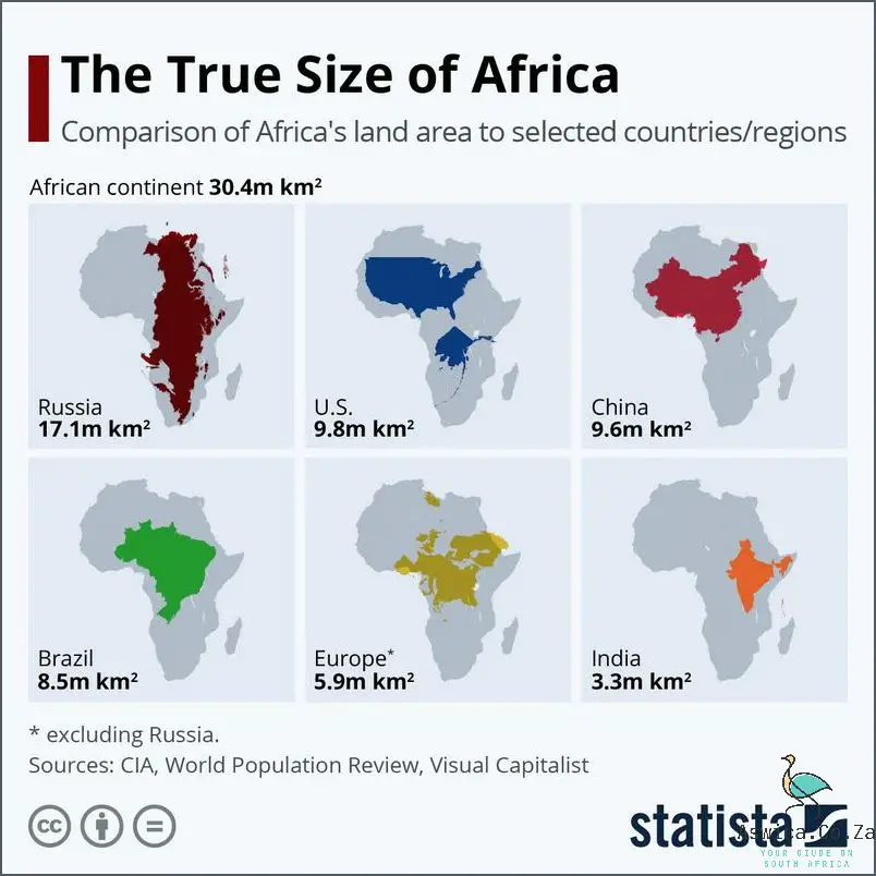
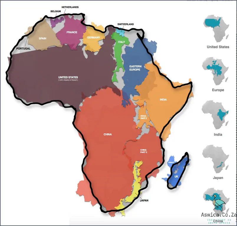
Furthermore, Africa is actually the second largest continent, with an area of over 30 million square kilometers. This is significantly larger than Europe, which is commonly believed to be the second largest continent. Additionally, North America is actually slightly larger than South America, and Antarctica is the fifth largest continent, despite being almost entirely covered in ice and snow.
The area of each continent also varies greatly when broken down into countries. For example, the size of the United States is larger than the entire continent of Europe. Similarly, the area of China is larger than the entire continent of Africa.
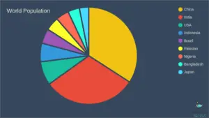
When looking at the continental areas in terms of population, Asia is the most populous continent with over 4.5 billion people. Africa is the second most populous, with over 1.3 billion people. Europe is the third most populous, with over 741 million people. North and South America have a combined population of over 1 billion people.
Despite the differences in size and population, each continent plays an important role in the global economy and international relations. Whether it’s the natural resources of Africa, the technological advances of Asia, or the economic power of Europe, each continent is vital to the world’s well-being.
So, next time you hear someone talking about the traditional estimates of the size of each continent, remember that the actual sizes may surprise you!
Conclusion
In conclusion, the actual sizes of continents are not as simple as they may seem. There is a lot of debate over how to measure them, and even more debate over which continent is the largest. In the end, it all comes down to personal opinion and interpretation.


