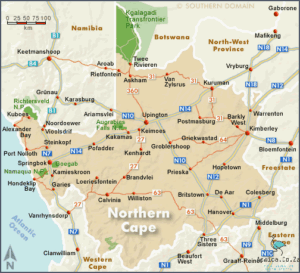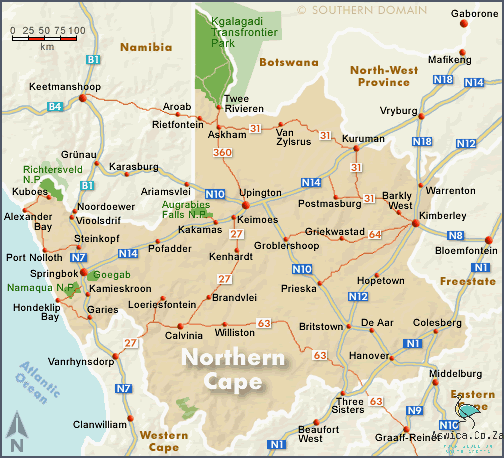
The Northern Cape Map is an essential tool for understanding the geography of the Northern Cape province in South Africa. It is used by locals and visitors alike to explore the area and understand its many features. The map is divided into districts, cities, towns, and villages, with each district having its own unique characteristics. It also includes major roads, national parks, protected areas, and other points of interest. The Northern Cape Map is the perfect companion for anyone interested in exploring this fascinating region of South Africa.
Contents
Northern Cape Map
The Northern Cape Map is a great tool for anyone looking to explore the area. It has a detailed overview of the entire province, which includes its main cities, towns and villages. It also provides information about its major roads, railways, rivers, mountains, and other important landmarks. The map is also a great resource for anyone looking to plan a trip to the Northern Cape, as it can provide them with a clear idea of the area's layout and attractions. Additionally, the map can help travelers find the best routes and destinations for their journeys, and it can also provide them with a great visual overview of the region. With its clear and concise presentation, the Northern Cape Map is an invaluable resource for anyone looking to explore the province.
Physical Geography of the Northern Cape
The Northern Cape, located in the western part of South Africa, is a vast region of wide open spaces and stark, breathtaking beauty. It is home to the most diverse physical geography of any province in the country, making it a fascinating area to explore and discover.
The Northern Cape is the largest of South Africa's nine provinces, covering an area of 372,889 sq km. It is largely an arid region, with an average annual temperature of 18 degrees Celsius. This region is home to a number of distinct physical features, including the Kalahari Desert, the Orange River, the Namaqualand Plateau, the Richtersveld and the Kgalagadi Transfrontier Park.
The Kalahari Desert is one of the most spectacular areas in the Northern Cape. This enormous desert is home to some of the most unique wildlife in the world, including meerkats, gemsbok, and the black-maned Kalahari lion. The Orange River, also known as the Gariep, is the longest river in South Africa, and is a vital source of water for the region. Along its banks, you can discover many species of birds, plants, and even the occasional crocodile.
The Namaqualand Plateau is a vast, dry, and rugged landscape of rocky hills, deep valleys, and arid plains. It is home to a number of endemic species, such as the African wildcat, meerkat, and the cape cobra. The Richtersveld is a mountainous region located in the northern part of the province and is home to the Nama people. This area is a protected World Heritage Site, and is renowned for its rugged beauty and rich cultural heritage.
Finally, the Kgalagadi Transfrontier Park is one of the most stunning protected areas in the Northern Cape. This park is home to the iconic Kalahari lion, and is a paradise for birdwatchers, with over 200 species of birds recorded in the park.
From the Kalahari Desert to the Richtersveld, the Northern Cape is a land of incredible variety and unique beauty. With its diverse physical geography and abundance of wildlife, it is a must-see destination for any traveler. So if you’re looking for the ultimate South African adventure, the Northern Cape is the perfect place to start.
Major Cities and Towns in the Northern Cape
The Northern Cape is a vast, sparsely populated province in South Africa, with a variety of diverse landscapes and numerous towns and cities that offer a unique experience to visitors. From the beautiful, mountainous region of the Kalahari to the wide open spaces of the Karoo, the Northern Cape is a place of beauty, culture and warmth.

The capital city of the Northern Cape is Kimberley, which is famous for its diamond mining industry and is the largest city in the province. The city has a lot to offer tourists, including a variety of museums, galleries and historic buildings, as well as a vibrant nightlife and restaurant scene.
Other major cities in the Northern Cape include Upington, Springbok and Kuruman. Upington is located in the beautiful Orange River Valley and is a great place to explore the region's wineries and national parks. Springbok is located in the Namaqualand region, which is known for its stunning wildflowers and is a popular destination for tourists. Kuruman is an oasis in the Kalahari Desert and is known for its sandstone formations and abundant wildlife.
The Northern Cape is also home to a number of smaller towns, such as Prieska, Alexander Bay, Kakamas, Pofadder and Douglas. These towns provide a great opportunity to explore the region's unique culture and history, as well as enjoy the unique landscapes of the region.
The Northern Cape is an incredible place to explore and offers a variety of experiences for tourists. Whether you're looking for outdoor adventure, cultural exploration, or simply a place to relax, the Northern Cape is a great destination for anyone looking to explore South Africa. From its major cities to its small towns and villages, the Northern Cape offers something for everyone.
Important Road Network in the Northern Cape
The Northern Cape is a vast and expansive province in South Africa, and its road network is an important part of its infrastructure. With its large size, it is necessary to have a reliable road network to help connect the far-reaching towns and cities of the Northern Cape.
The N1 is one of the most important roads in the Northern Cape, running from the provincial capital of Kimberley to the border with the Free State. This road cuts through the heart of the province, connecting the main towns of Upington, Kuruman, and Douglas. It is also connected to the N12, which runs from the Namibian to the South African border, and from there to the N14, which links the province to the capital of Gauteng.
The N14 is another important road in the Northern Cape. It runs from the port city of Port Nolloth to the provincial capital, linking the western and eastern sides of the province. It also connects to the N7 highway, which runs from the Namibian border to Cape Town.
Another important road in the Northern Cape is the N10, which runs from Upington to the Namibian border. This road links the eastern and western parts of the province, as well as connecting to the N14. It is also connected to the N11, which runs from the Namibian border to the Orange River.
The N18 is also an important road in the Northern Cape, as it connects the province with the Free State and the Western Cape. This road links the towns of Upington, Springbok, and De Aar. It is also connected to the N12, which runs from the Namibian border to the South African border, and from there to the N14.
The Northern Cape has a number of other important roads that help to connect its towns and cities. The N13 connects the towns of Kuruman and Upington, while the N19 links the provincial capital with the Kalahari desert. The N2 links the port city of Port Nolloth to the provincial capital, while the N9 links the provincial capital to the eastern border.
The Northern Cape's road network is an essential part of its infrastructure, and it is important for the province's economic development. It not only helps to connect the towns and cities of the province, but also provides access to essential services and amenities. It is vital that the road network is maintained and improved to ensure that the province remains connected and able to access resources.
Conclusion
The Northern Cape map is an invaluable tool for exploring the province and understanding its unique geography. It clearly outlines the major roads, cities, and towns of the region and provides an easy way to gain an understanding of the area. Additionally, the map shows the major rivers, lakes, and other bodies of water and provides a visual reference for locating points of interest. With its detailed and informative layout, the Northern Cape map is a great resource for anyone interested in learning more about the region.


